Space-based Earth observation (EO) has transformed how we understand our planet. From tracking sea level rise and deforestation to monitoring soil moisture, ocean salinity, and magnetic field variations, EO missions have become essential tools for science, policy, and global sustainability. And yet, look closer at the technologies behind these missions, and a striking pattern emerges.
For most of the past 60 years, EO has relied heavily on spin-in: the adaptation of technologies originally developed for other domains (e.g. defense radar, astronomical spectrometers, navigation systems, or laboratory sensors). This approach was practical. It leveraged mature technologies. It reduced risk. And it worked, while the science questions could still be addressed using instruments that already existed.
I claim that this era is ending.
Today’s EO needs, resolving fine-scale greenhouse gas sources, detecting subtle changes in ecosystem health, or monitoring groundwater from space, often exceed the capabilities of existing sensors. The next wave of missions depends on technologies that are still emerging: in quantum sensing, ultra-miniaturized optics, novel spectral techniques, or onboard AI. These technologies won’t be handed to EO from other domains. They need to be identified, evaluated, shaped, and supported within the EO community, before they reach full maturity.
That shift demands a new kind of framework: one that tracks how far a technology has progressed in becoming mission-relevant, even when it’s still early in its development. I call this framework Innovation Readiness Levels (IRL) (KTH uses this term to envelope multiple dimensions of readiness: https://kthinnovationreadinesslevel.com/)
In this post, I explore why EO needs IRLs now and how they can help agencies, researchers, and technologists bridge the critical gap between invention and orbit.
The Legacy: Riding the Spin-In Wave
Nearly every core EO instrument in use today began as a solution to a problem in a different field:
- Radar altimeters originated in military aviation during the 1930s and 40s, designed to help aircraft maintain altitude during night or bad weather.
- Synthetic Aperture Radar (SAR) was pioneered for all-weather battlefield imaging and reconnaissance, later adapted to map ice sheets, forests, and deformation fields.
- GNSS receivers (used in GNSS reflectometry and radio occultation) were designed for precise positioning, only later adapted for sensing atmospheric profiles and surface reflections.
- Microwave radiometers trace their roots to astrophysics and defense research on microwave background noise and weapon detection.
- Infrared radiometers were originally developed for thermal surveillance, target tracking, and astronomy—long before they were used to measure sea surface temperatures or land surface fluxes.
- Lidar systems were originally built for military ranging and aircraft altimetry, not vegetation structure or snow depth measurement.
- Fluxgate magnetometers were developed in the 1930s for detecting submarines and later used in geophysical surveys to map the ocean floor.
This spin-in strategy worked when: There was a large pipeline of technologies developed for other purposes, EO questions could be answered using those tools and agencies could afford to wait for technologies to prove themselves elsewhere. But that model has consequences. The lag between invention and mission use is often 20–40 years. And promising EO-specific technologies, those without a “parent field” to prove them, risk being left behind.
The Shift: Strategic Tech Adoption
Earth observation is no longer in its infancy. The field has matured into a global infrastructure—feeding climate models, supporting international policy, and underpinning environmental services. But with maturity comes new responsibility: the need to proactively shape the technologies that will power the missions of the next 10, 20, or even 50 years. The days of waiting for a military radar or lab spectrometer to become “EO-ready” are over. The questions Earth scientists are now asking demand instruments that don’t yet exist. At the same time, technological possibilities are expanding:
- Quantum sensors for gravimetry and magnetometry
- Integrated photonics for compact, ultra-stable spectroscopy
- Onboard AI for adaptive tasking and edge processing
- Miniaturized lidar for 3D canopy structure and bathymetry
These innovations arise in physics labs, optics startups, and national research programs. To bring them into the EO pipeline, space agencies must shift from passive adoption to strategic evaluation and nurturing, starting long before a mission is defined.
Agencies are beginning to recognize this:
- NASA’s Earth Science Technology Office (ESTO) funds advanced concepts, including quantum and AI-based payloads.
- ESA’s FutureEO and InCubed programs explicitly aim to scout high-potential technologies.
- The 2022 NASA Decadal Survey calls for technology assessments “before requirements are fully defined.”
But despite these efforts, there’s no common framework to structure this early-stage process. That’s the missing piece: not just funding, but a readiness model for understanding how close an emerging technology is to becoming part of a real EO mission. This is where Innovation Readiness Levels (IRL) come in.
Introducing Innovation Readiness Levels (IRL)
The gap between invention and mission is where most technologies stall. A sensor may work beautifully in the lab, but without a structured path to show how it could enable a real Earth observation mission, it often goes no further. That’s because the tools we currently use, like Technology Readiness Levels (TRL), only formally apply after a mission concept exists and system requirements are defined. Before that, TRLs are used as a proxy and are crucial for engineering maturity, but they don’t help us answer the more strategic question:
Is this technology becoming relevant enough to shape a mission?
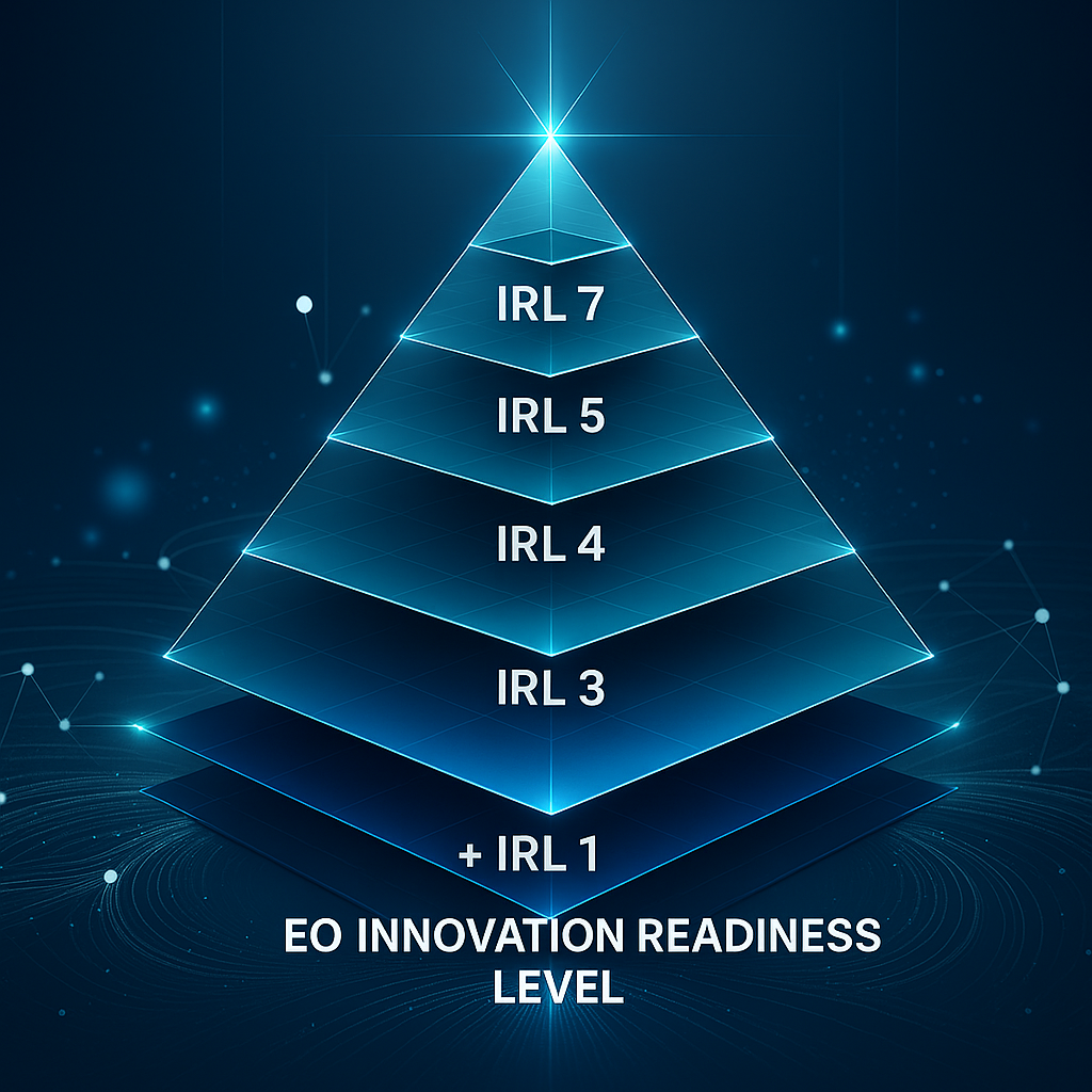
This is the purpose of Innovation Readiness Levels (IRL). IRL is a 7-level scale that tracks a technology’s journey from a promising new capability to a candidate for mission integration. It focuses not on technical validation, but on mission relevance maturity, the work required to make a technology thinkable, credible, and selectable for EO use. Here’s the scale:
| IRL | Stage | What Has Been Achieved | Typical Activities Performed |
|---|---|---|---|
| 1 | Discovery | A technology performs a function that could be relevant to EO. EO relevance is noticed, either through intent, observation, or application scouting. | Exploratory lab work, cross-domain tech scouting, literature review, early demos in unrelated fields. |
| 2 | Use Case Framing | Specific EO use-cases are outlined where this function could enable new measurement or capability. | Mapping to EO variables/domains, conceptual matching, science-user consultations, workshops. |
| 3 | General Performance Assessment | Early evidence suggests the technology might meet relevant performance needs. | Bench testing, modeling, sensitivity analysis, lab prototypes, SNR or resolution studies. |
| 4 | Mission Concept Identification | One or more mission concepts are defined in which the technology plays an enabling role. | Orbit and architecture trade studies, payload concept notes, pre-Phase 0 white papers. |
| 5 | Mission Value Assessment | System-level studies demonstrate that the technology is mission-enabling and offers clear performance or cost advantages for a specific EO use-case, beyond demonstration value. | Coverage simulation, retrieval chain modeling, value-of-information studies, baseline comparisons. |
| 6 | Concept Maturation for Selection | A full proposal or concept package is ready for agency or program-level review. | Mission proposal writing, team-building, cost/resource planning, interface and system design drafting. |
| 7 | Study Selection | The technology is included in a selected Phase 0/A study or implementation path. | Formal submission, agency evaluation, selection into funded study phase (e.g. ESA EE Phase-0, NASA EV-A). |
Why IRL Matters
- It gives technologists a clear map of the steps needed to move from lab to mission.
- It allows agencies to support innovation earlier, before specific calls or requirements are in place.
- It helps reviewers, funders, and planners distinguish between raw potential and real momentum.
- And it provides a way to coordinate innovation efforts across disciplines—bringing in optics, quantum sensing, or AI on their own terms.
In short: IRL makes the invisible part of EO innovation visible. In the next section, we’ll see how IRLs played out, implicitly, in 6 case studies. Then we’ll discuss how formalizing the scale could change the trajectory of Earth observation technology in the years ahead.
Case Studies: How EO Technologies Quietly Climbed the IRL Ladder
To see how Innovation Readiness Levels work in practice, let’s look at a few traditional and modern examples.
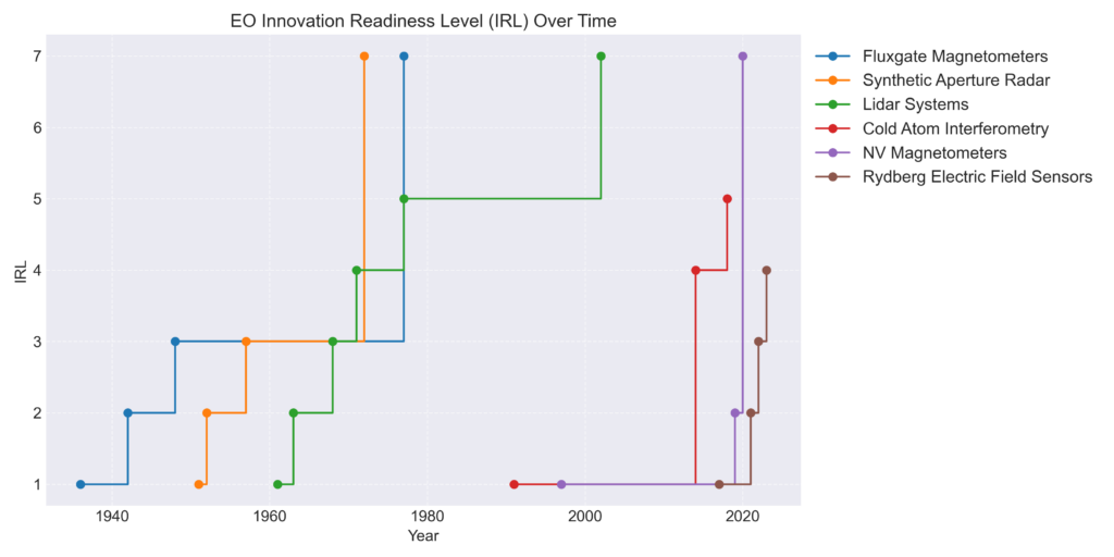
| IRL | Year | Event |
|---|---|---|
| 1 | 1936 | In 1936 Aschenbrenner & Goubau invented the fluxgate magnetometer, demonstrating a new way to measure weak magnetic fields sciencenews.org. This is the first recognition of a technology capable of sensing Earth’s magnetic field. |
| 2 | 1942 | By December 1942, Vacquier’s portable fluxgate had proven effective for detecting submarines from aircraft sciencenews.org. The US Navy articulated the value of this magnetic sensing (marine anomaly detection) as a practical Earth-survey application. |
| 3 | 1948 | In 1948 researchers towed an airborne fluxgate (“magnetometer fish”) across the Atlantic and successfully mapped seafloor magnetic stripes johnmilsom.online. These experiments showed the fluxgate could meet requirements for Earth science (plate-tectonics evidence). |
| 7 | 1977 | Magsat project is approved and the fluxgate magnetometer is baselined into its design. |
| IRL | Year | Event |
|---|---|---|
| 1 | 1951 | In June 1951, Carl Wiley at Goodyear Aircraft invented synthetic-aperture radar, showing that moving-platform radar can achieve fine angular resolution en.wikipedia.org. This was the first recognition of SAR’s basic functionality. |
| 2 | 1952 | In 1952, a Department of Defense study (Project “TEOTA”) explicitly identified Doppler-assisted SAR concepts for ground reconnaissance en.wikipedia.org. This articulated an Earth-observation use-case (detailed land/shore surveillance) for the emerging SAR technology. |
| 3 | 1957 | By August 1957, Project Michigan obtained the first focused airborne SAR image of Willow Run Airport, achieving ~15 m resolution from a 1.5 m antenna en.wikipedia.org. This demonstrated SAR’s performance potential in meeting EO needs (terrain mapping). |
| 7 | 1972 | NASA/JPL studies the Seasat oceanography satellite concept, including a spaceborne SAR for Earth surface imaging earth.esa.int. |
| IRL | Year | Event |
|---|---|---|
| 1 | 1961 | In 1961 Hughes Research Labs built the first laser radar (“LIDAR”) prototype toddneff.com. This was the first instance that laser ranging could be considered to perform an Earth-relevant sensing function. |
| 2 | 1963 | By 1963 SRI International’s Mark I LIDAR demonstrated profiling of the lower atmosphere (detecting clouds, smog, haze) toddneff.com. This articulated an EO use-case (aerosol/climate monitoring) for laser remote sensing. |
| 3 | 1968 | In 1968 researchers flew a lidar over Lake Ontario to measure water depth (bathymetry) toddneff.com. The success of this airborne LIDAR survey showed the technology’s potential to meet coastal-mapping needs. |
| 5 | 1977 | In 1977 NASA’s Airborne Oceanographic Lidar (AOL) flew its first surveys of shorelines and sea surface toddneff.com. These flights validated system performance for altimetry and depth sounding, confirming clear EO value for ocean/shore mapping. |
| 7 | 2002 | By the early 2000s, NASA had baselined the ICESat mission and its GLAS laser altimeter into its Earth-observation programs, indicating official adoption of LIDAR for polar and terrain altimetry. (Mission approvals and instrument selection were completed around this time.) |
| IRL | Year | Event |
|---|---|---|
| 1 | 1991 | Kasevich & Chu demonstrate an atom-interferometer gravimeter in the lab ar5iv.org, showing that laser-cooled atoms can serve as high-precision inertial sensors. This first proof-of-principle shows cold-atom sensors can measure gravitational acceleration, a function directly relevant to geodesy/EO. |
| 4 | 2014 | Carraz et al. publish a mission concept for a spaceborne cold-atom gravity gradiometer link.springer.com. Their design uses dual Bose–Einstein condensates and interferometers to map Earth’s gravity gradients, directly integrating cold-atom sensors as the core payload. This formal concept study is the first proposal to include cold-atom interferometry as a core enabling payload for an EO mission. |
| 5 | 2018 | Douch et al. perform end-to-end simulations of a CAI-based gravity gradiometer mission hal.sorbonne-universite.fr while assuming beyond state-of-the-art attitude control performance. They benchmark the CAI system against ESA’s GOCE results and show it can improve recovery of the static gravity field. These system-level studies (e.g. gravity field inversion from simulated data) demonstrate clear EO value of the concept under realistic mission scenarios. |
| IRL | Year | Event |
|---|---|---|
| 1 | 1997 | Gruber et al. achieve the first room-temperature optical detection of a single NV center’s spin in diamond en.wikipedia.org. This proved that NV centers could be initialized and read out as quantum spin sensors, laying the foundation for their use as highly sensitive magnetometers. |
| 2 | 2019 | NV-diamond magnetometers are identified for geomagnetic EO by SBQuantum (Canada) for Phase 1 of the Magquest challenge magquest.com. |
| 7 | 2020 | SBQuantum and Spire Global merge to develop a joint solution to update the world magnetic model within the magquest challenge magquest.com. |
| IRL | Year | Event |
|---|---|---|
| 1 | 2017 | Sedlacek et al. (and others) demonstrate atomic vapor electrometry via Rydberg-EIT with μV/cm RF sensitivity nature.com. This first lab validation shows Rydberg atoms can serve as electric-field sensors (analogous to antennas), establishing the basic sensing function for EO (e.g., passive microwave remote sensing). |
| 2 | 2021 | A NIST-authored review highlights Rydberg-atom RF-field sensing as a promising new metrology nist.gov. It notes Rydberg detectors provide SI-traceable, broadband field measurements with very high sensitivity. This survey articulates concrete EO-relevant use-cases (e.g. wideband radar, communications spectrum) for Rydberg sensors, indicating community recognition of their value. |
| 3 | 2022 | Arumugam et al. demonstrate remote sensing of soil moisture by using a Rydberg vapor cell tuned to satellite radio signals nature.com. This proof-of-concept (ground-based reflectometry with Rydberg receivers) shows the technique can retrieve an EO variable (soil moisture) using signals-of-opportunity. It provides direct performance evidence that Rydberg sensing can fulfill an EO measurement. |
| 4 | 2023 | NASA funds the “Quantum Rydberg Radar (QRR)” NIAC project nasa.gov. QRR is a mission concept for a Rydberg-based spaceborne radar covering 0.1–22 GHz on a single compact sensor, targeting Earth Science (topography, hydrology, etc.). By proposing a concrete mission architecture (and covering multiple science objectives), this formal concept study places Rydberg sensing at the core of a next-gen EO radar payload. |
While tracing the innovation histories of several EO technologies, a clear pattern emerged: the middle stages of readiness – IRL 3 to 6 – are often invisible to the community. Invention and early demonstrations are typically well-documented, and full mission launches are public milestones. But between them, key activities like performance validation, mission framing, and simulation work tend to happen off-stage, scattered across papers, workshops, or internal studies.
As a result, technologies may appear less mature than they are, simply because no one labels these transitions. This is not a flaw in the IRL framework, but a reflection of practice: we don’t consistently signal or document when a technology becomes mission-relevant.
Making these mid-stage steps more visible – through lightweight declarations or shared case studies – could help agencies and the community recognize readiness earlier, and act on it more confidently.
Another observation is the rapid maturation of the NV magnetometers through the Magquest challenge. While the magnetometer technology-infusion into existing magnetometry mission concepts and the sensor itself have comparably low complexity, this advance is remarkable and signals the utility of open innovation challenges.
The Case for Adopting Innovation Readiness Levels
The case studies are clear: even breakthrough technologies take decades to reach Earth observation missions – not because they lack potential, but because there is no formal structure to guide their adoption. That’s the gap IRLs are meant to fill. What TRL can’t do is help answer early questions like:
- Is this technology beginning to solve an EO-relevant problem?
- Are use cases credible and performance expectations plausible?
- Has anyone shown that it could work in an end-to-end mission concept?
- Is it ready to shape a proposal or support Phase 0 study?
IRLs give the EO community a tool to:
- Track early-stage innovation systematically, from discovery to study selection
- Make transparent decisions about where to invest in further development
- Structure calls and reviews to encourage well-formed but still-emerging ideas
- Reduce time-to-mission by preparing technologies earlier for inclusion
and finally also enable funders to distinguish between:
- Promising technologies stuck at IRL 2 (no EO use-case)
- Well-performing candidates at IRL 3 (but with no mission framing)
- Concepts with clear EO value and architectural potential (IRL 5+)
Agencies could:
- Include IRL self-assessments in early-stage proposal templates
- Develop guidelines and examples for each level
- Use IRLs internally to manage innovation pipelines
- Align funding, mentoring, and support to help technologies climb the IRL ladder
Closing Thought
The first era of EO innovation was built on adaptation. The next must be built on deliberate adoption, based not only on what technologies are ready to fly, but on which are ready to matter. Innovation Readiness Levels offer a path forward: a bridge between new ideas and future missions. It’s time we start using it.
No responses yet